

The Department for Culture, Media & Sport (DCMS) has just published Turn It Up: Our plan for music [1]. It represents the most ambitious strategy for music in over a decade, asking a set of important questions about how to secure a thriving music industry, widen opportunity, and use music to strengthen communities and local economies across the UK.
The Plan commits £45 million to a Music Growth Package, in addition to £12.5 million to transform libraries into music hubs, and £10 million for creative mentoring targeted at underrepresented young people. It also backs a voluntary £1 arena levy for shows over 5,000 capacity directing proceeds into the grassroots ecosystem.
Crucially, the Plan acknowledges that rising costs, slim margins (of just 2.5% for grassroot venues), and shifting audience behaviours are placing increased pressures on the very foundations of the live music sector. It recognises that small venues have not received sufficient investment and argues that access to live music should be available “wherever people are in the UK”.
This is a welcome shift, and lands at a moment of significant political change. The new Prime Minister has been clear in his early messaging of “local first”. His agenda thus far, has emphasised empowering local areas to revive high streets, support SMEs, and reform business rates to create fairer conditions for local businesses. Live music, and the venues that sustain it, sit squarely within this agenda.
Against this backdrop, this blog explores a key question; why do towns and cities’ economies depend so much on grassroots music venues, and do these venues depend on the wider urban ecosystem in return?
Reflecting on Lichfields’ work supporting the arts, culture and music across the UK, in addition to insights from the recently held Hull Music Cities Convention [2], four themes stand out.
Grassroots venues are essential infrastructure, not ‘nice to have’
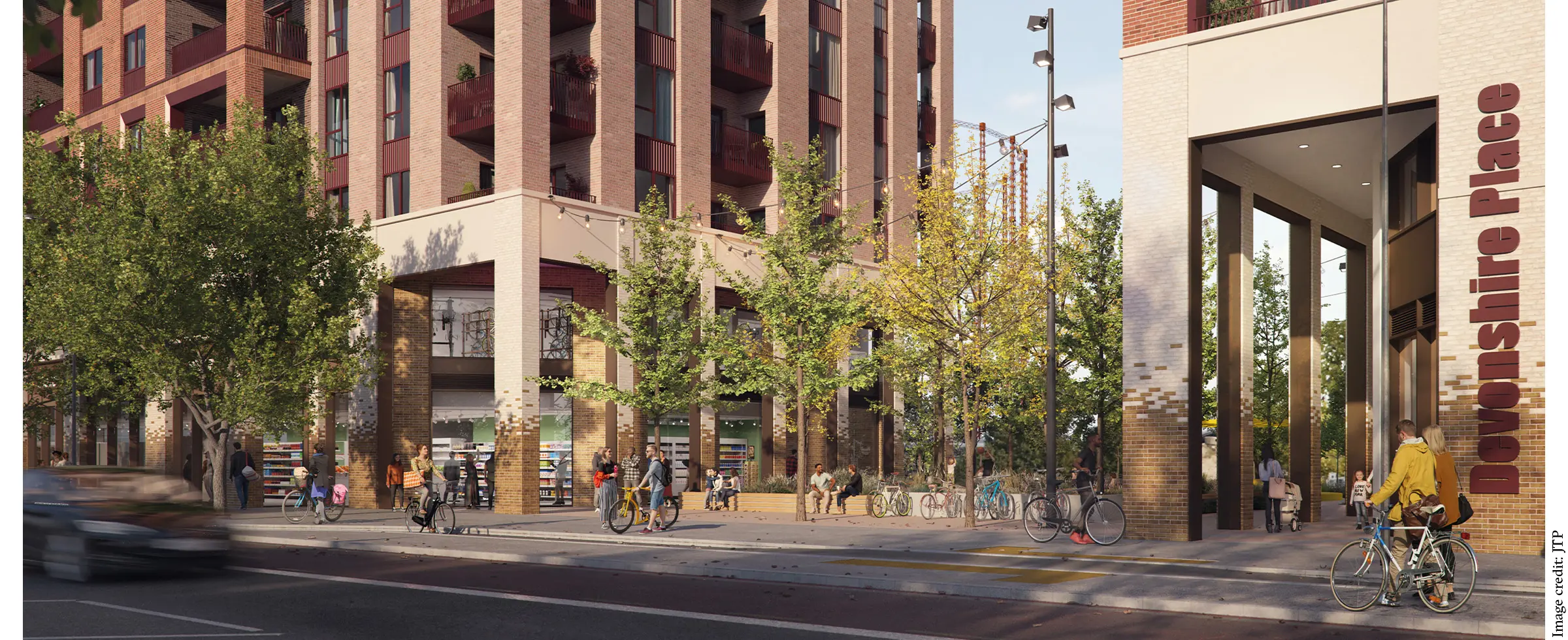
Turn It Up rightly positions grassroots venues as the bedrock of the UK’s music ecosystem. They are where artists, crew members and promoters learn their craft, where communities gather and where local identity is formed. They are also where the night-time economy begins; generating cultural energy, animating town centres and building civic pride.
Yet for years, these venues have been treated as somewhat peripheral, or sometimes even as a nuisance to be managed. Licensing regimes have constrained opening hours, impacting their vitality and driving audiences away. Additionally, investment has flowed disproportionately to larger-scale venues, with many grassroots venues being forced to shut.
The Government’s Plan begins to correct this imbalance; however, the underlying principle is bigger than any single intervention. A thriving night-time economy cannot exist without thriving grassroots venues; one cannot function without the other. For example, a recent article in The Guardian [3] highlighted how London is rapidly losing its nightlife (and consequently its night-time economy) due to increasingly restrictive licensing policies, particularly through the widespread enforcement of “core hours”, effectively imposing a council-mandated bedtime for the night-time economy.
Turn It Up acknowledges this. Grassroots venues are not simply cultural assets; they are important economic catalysts. They drive footfall, animate high streets and create the conditions for other adjacent industries (such as hospitality, retail and transport) to thrive. In other words, they provide the spark that activates the rest of the night-time economy.
Economic impact matters, but it’s not the whole story
Turn It Up emphasises the £8 billion contribution of the music industry to the UK economy. This is important, but is only one dimension of value.
At the recent Hull Music Cities Convention, presenters repeatedly suggested that economic impact should not be regarded as the sole measure of success. While in today’s environment, economic impact matters more than ever, it is correct to say that it is also important to capture cultural identity, emotional value, inclusion, belonging and community cohesion.
Lichfields’ work with clients across the industry reinforces this. When assessing the impact of construction and first year operations at Co-op Live in Manchester [4], we found that economic impact (measured in terms of gross value added) represented only a fraction of the venue’s wider contribution. The real value lay in confidence, aspirations, community pride and the catalytic effect of kickstarting the regeneration of East Manchester. This is something the new Prime Minister will be all too familiar with.
This is where Turn It Up is, perhaps, less explicit. The Plan acknowledges the civic role of music, but underplays the emotional and wider societal value that live experiences generate. Fortunately, emerging research fills this gap.
The Goosebumps Effect, and why live music matters to communities (and economies)
A recent study, The Goosebumps Effect [5], provides compelling evidence for the emotional and social value of live experiences. It shows that shared moments can increase empathy, reduce anxiety, strengthen social cohesion and build collective resilience.
A visceral, example of this was experienced by many during the 2017 memorial following the Manchester Arena attack [6], where one song – Don’t Look Back in Anger – brought people together and provided the resilience needed for the community to begin healing.
This effect matters; it shows that live music is not just entertainment but provides the emotional framework required to create belonging and wider community trust. Ultimately, it has potential to strengthen the social fabric that underpins local economies. At the grassroots level, the proximity and intimacy of smaller venues amplify these effects.
If we want a thriving night-time economy, we must therefore measure (and invest in) these forms of value. Economic impact must therefore include societal impact within it.
Building a strong night-time economy requires ecosystem thinking
One of the clearest messages from the Hull Music Cities Convention was simple; you have to be intentional to be inclusive. This message applies equally to building a music city, as well as a night-time economy. Neither is a collection of isolated assets. They are an ecosystem where transport, licensing, skills, community safety, affordability and cultural infrastructure all meet and interact.
Turn It Up opens the door to this kind of thinking by supporting more flexible licensing, investment in grassroots infrastructure and widening access for young people. However, success will require places to build on this foundation. It will require councils, venue operators, promoters and economic development professionals to stop thinking in silos and start thinking in systems.
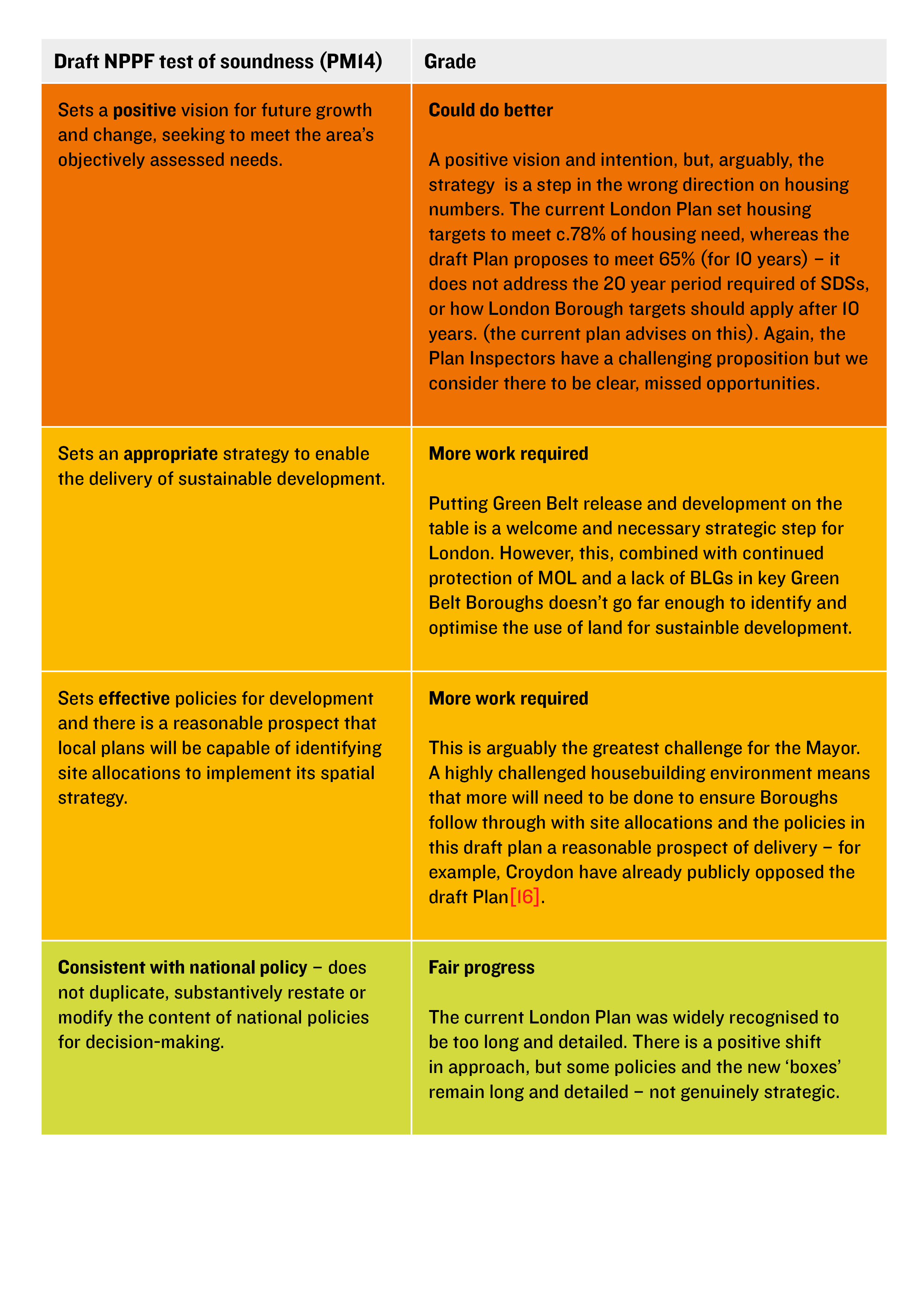
It will also require balancing venue operations with residents’ needs. The recent “debate” between the Mayor of London and the Soho Residents’ Society [7] shows how essential it is to balance cultural vibrancy with residential amenity. The Draft London Plan [8] – currently out for consultation – reinforces this direction. Policy GLE4 Night-time economy seeks to boost economic activity in hospitality, culture, nightlight and events, whilst also protecting and future-proofing night-time areas from sensitive uses by deploying the Agent of Change principle. In addition, the Draft London Plan also makes the case for greater integrated coordination across planning, licensing and transport to ensure a thriving 24-hour economy.
This is ecosystems thinking in practice, and putting grassroots venues central to this equation aligns closely with the Prime Minister’s early ‘local first’ message that a thriving national economy begins with strong local foundations.
A brave new order, but the work starts at the bottom
Turn It Up provides a starting point and the platform for strengthening the UK’s music ecosystem. It recognises the importance of grassroots venues to widen opportunity and start addressing some of the structural challenges facing towns and cities.
But its success depends on whether places can embrace a bottom-up approach; one that values emotional and societal impact alongside economic metrics, and treats music as the tide that lifts all boats. This aligns closely with the Prime Minister’s early messaging. A modern music policy (and consequently a modern night-time economy) must reflect this.
If we want cities that thrive, and night-time economies that are vibrant, safe and resilient, we must start where music begins – the grassroots venues that give places their identity and their confidence.
And we must also build an ecosystem around them; intentionally, collaboratively and from the ground up. A brave new order starts at the bottom.
Footnotes
[1] DCMS (2026), Turn It Up: Our plan for music [Link]
[2] Hull Music Cities Convention [Link]
[3] Bedtime blues: London ‘killing off nightlife’ as UK city with strictest licensing rules [Link]
[4] Co-op Live contributes over £1.3 billion turnover to UK economy since inception [Link]
[5] The Goosebumps Effect [Link]
[6] See [Link]
[7] Sadiq Khan vows to overrule residents’ group’s objections to Soho bars and restaurants [Link]
[8] Mayor of London (2026), Draft London Plan [Link].