The Green Belt is one of the most politically emotive topics in town planning. People’s understanding of the Green Belt helps fuel this political heavyweight today, but to what extent does this understanding reflect reality?
The Green Belt’s original three principles include health, convenience and beauty. On health, Ebenezer Howard envisaged towns surrounded by countryside to separate housing from industry in the context of polluted Victorian cities. Raymond Unwin proposed convenient access to countryside for city dwellers through the provision of recreational space at the edge of the urban area and as part of the 1945 Greater London Plan, Abercrombie included a Green Belt ring around London to conserve beauty by stopping encroachment of the capital into the countryside. If the Green Belt lived up to these three principles then there is a strong case for its retention. But to what extent does the Metropolitan Green Belt fulfil these principles?
Howard’s idea to separate housing and industry for health benefits was obviously positive at the time, but over a century later, the Green Belt’s impact on health needs a more contemporary view. London reached its population peak at 8.6 million people in February 2015 with no signs of stopping. In this context, London is seemingly aiming to do everything it can to deliver more than double the past rates of housing delivery over the next decade within its finite boundaries defined by the Green Belt, but even if successful on its own terms, this still leaves a shortfall of at least 7,000 homes every year. Implications of London’s housing shortfall are already evident, between 2001 and 2011 overcrowding in London increased by 25% and concealed households soaring by 70%. The health implications of more and more people cramming themselves into overcrowded accommodation in London are well documented.
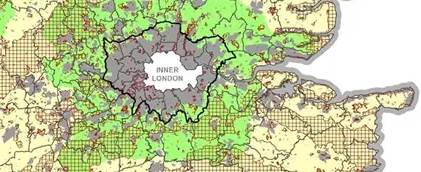
The use of Green Belt land for the pursuit of leisure conjures much public support, but the Green Belt is not geared towards public access. Non-accessible agricultural land covers 59% of the Metropolitan Green Belt and a further 7.1% is occupied by (mainly private) golf courses. Only 13% of the entirety of the Metropolitan Green Belt is publically accessible. Furthermore, today there are competing demands for how people spend their leisure time and these may not include access to the great outdoors, instead maybe opting for the gym. Equally, today increased public transportation and car ownership mean that access to open countryside nearby is no longer the imperative it once was.
Few would dispute that the protection of scenic English countryside from visual erosion of development is a good thing. But the planning system offers this protection through designations including Areas of Outstanding Natural Beauty and Sites of Special Scientific Interest
[1]. In fact, just 31.3% of non-urban land in the Metropolitan Green Belt is covered by NPPF footnote 9 constraints
[2] (in the Metropolitan Green Belt 24% is AONB, 5% SSSI and less than 1% Local Nature Reserves), compared to 34.3% outside of the Green Belt. It is also true that there are numerous brownfield sites within land designated as Green Belt.
In summary, although the original purposes of Green Belt might seem valid today, the reality is the Green Belt is likely to be peripheral to the achievement of these ideals. There are clear health implications of overcrowding cities where development opportunities are constrained. Green Belt designation does not guarantee public access and nor is this space necessarily a demand of peoples leisure time. Finally, swathes of the Green Belt are in fact brownfield sites or are not deemed worthy of other planning designations defining beauty or interest. Has the time has come for the belt to be loosened on this utopian misconception?
[1] Along with other NPPF footnote 9 constraints.
[2] Sites protected under the Birds and Habitats Directives , Sites of Special Scientific Interest, Green Belt, Local Green Space, Area of Outstanding Natural Beauty, Heritage Coast or National Park (or the Broads Authority), designated heritage assets; and locations at risk of flooding or coastal erosion.


