
Against the backdrop of a challenging economic outlook, declining state of public finances and growing global geopolitical uncertainty, the Chancellor of the Exchequer’s Spring Statement 2025 was an important opportunity for the government to demonstrate a firm handle on the economy and a credible plan for delivering their “number one mission” for growth.
Having previously downgraded it to a ‘spring forecast’, the rapidly changing global context since the Budget was delivered last Autumn meant that Rachel Reeves’ speech in the House of Commons on Wednesday became much more significant.
As widely anticipated, the latest forecasts from the Office for Budget Responsibility (OBR) have downgraded UK economic growth to just 1.0% during 2025, which is half the rate expected back at the time of the Autumn Budget. Growth is then forecast to increase to 1.9% during 2026 and has been upgraded slightly in cumulative terms across the forecast period to Q1 2030.
Scarce pickings for public investment
Amidst the various cross-cutting spending cuts confirmed by the Chancellor, there were no ‘new’ announcements or funding commitments specifically in relation to planning and development.
Nevertheless, the Chancellor was keen to emphasise government’s “serious plan for growth”, citing some of the recent announcements already made to boost the economy including support for a third runway at Heathrow airport and £2 billion of grant funding to deliver up to 18,000 new social and affordable homes[1].
This follows the granting of development consent by the Secretary of State on Tuesday for the Lower Thames Crossing, and allocation of £600 million worth of investment to train up to 60,000 more skilled construction workers to help achieve government’s target to build 1.5 million homes in England by the end of this Parliament.
Planning reform remains in pole position
Planning reform was reiterated as being key to achieving this plan for growth, with the government’s flagship Planning and Infrastructure Bill having passed its second reading in the House of Commons on Monday.
The Chancellor was delighted to share the OBR’s conclusion that the planning reforms included in the updated (December 2024) National Planning Policy Framework (NPPF) will lead to 170,000 additional homes being built over the forecast period (i.e. to 2029-30), in turn increasing the level of real GDP by 0.2% and adding £6.8 billion to the economy (in today’s prices)[2].
This reflects the biggest positive real GDP effect that the OBR has ever reflected in its forecast for a policy with no fiscal cost. More explicitly, it shows that changes to the planning system have the potential to play a major role in driving economic growth if they can be implemented effectively.
In cumulative terms, the OBR expects net additions to the UK housing stock will amount to 1.3 million from 2025-26 to 2029-30, reaching 305,000 a year by 2029-30 (as shown in Figure 1 below).
Figure 1: Net additions and private housing completions
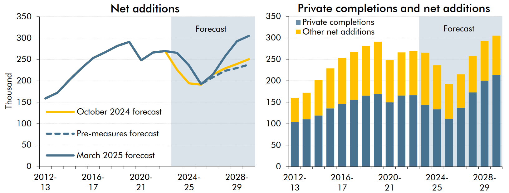
Source: Office for Budget Responsibility, Economic and fiscal outlook (March 2025)
This would see housebuilding reach its highest level in over 40 years and put the government within “touching distance” of achieving its manifesto promise of 1.5 million new homes by the end of this Parliament (albeit the 1.5 million target relates to England only, so in reality the ‘shortfall’ could be more significant).
Signs of a broader economic plan?
The Spring Statement was an obvious opportunity to back these planning reforms with specific measures to kick start economic activity and move the focus beyond house building. We are still awaiting the government’s full Industrial Strategy (following publication of the Green Paper ‘Invest 2035’ in October 2024) which will set out a 10-year plan for investing in the high growth sectors that will drive government’s growth mission. This is due to be published in ‘Spring 2025’, alongside Sector Plans for eight growth-driving sectors and aligned with the multi-year Spending Review.
The economic role of defence
In advance of this, the Chancellor set out a series of initiatives and funding commitments to boost Britain’s defence industry as way of achieving economic growth alongside maintaining national security. In particular, leveraging the additional £2.2 billion defence spending announced in the Spring Statement to invest in defence technology and innovation.
This includes establishing UK Defence Innovation (UKDI) to enable innovative technology to rapidly progress from idea to the front line to secure competitive advantage and wider economic spillovers.
A new Defence Growth Board, co-chaired by the Chancellor and Defence Secretary, aims to put defence ‘at the heart of the UK’s modern Industrial Strategy’, as the country develops its credentials as a “defence industrial superpower” armed with the skills, jobs and economic opportunities to strengthen the UK and drive economic growth.
Specific growth and investment locations were identified in the Spring Statement including the Cumbrian town of Barrow-in-Furness (home to defence giant BAE Systems), alongside a commitment to regenerate and secure the future of Portsmouth Naval Base. Given that defence spending has historically focused on south western and south eastern parts of the country (as shown on the interactive map below), the government will need to carefully consider how this top-down investment into defence priorities can deliver economic growth and opportunity for all parts of the country.
One down, seven sectors to go
Defence is rightly highlighted in Invest 2035 but represents just one of its eight priority growth sectors[3]. The country’s business communities are eager to learn more about the government’s plans for them all. Similarly, local authorities including proposed Strategic Authorities are anxious to understand their role and priorities in enabling the sectors to grow. Whilst it is understandable for the Chancellor to emphasise that “the world has changed”, we suspect that the apparent delay to the publication of the final Industrial Strategy and associated Sector Plans relates to the disappearing prospect of sufficient fiscal headroom needed to stimulate investment anytime soon.
The sector-focused approach is positive, logical and meaningful in economic policy terms. However, if the government genuinely intends to ‘tackle barriers to growth’ and ‘create the right conditions for increased investment and higher quality jobs’, public sector capital will be required. Taking the creative industries as an example, it would be revealing to see how much investment is required simply to keep existing regionally and nationally important cultural assets operational and economically productive (not unlike the country’s tired and under-invested infrastructure system – from potholes to ubiquitous water leaks). This is before consideration is given to the capital support required, for example, to ensure affordable workspace is available for new creative enterprises throughout our cities, skills programme put in place to deliver the modern workforce needed for growing sectors or targeted funding gaps filled to ensure the next generation of theatres, arts and music venues can be realised.
The role of planning in industrial strategy
Whilst government borrowing may provide an element of the investment required in the short-term, the growth community will need to be patient. In the meantime, the government should continue to make best use of the policy levers it has at its disposal to release latent private sector capital investment. Planning reform coupled with a direct relationship to economic development policy is probably one of the most potent tools available to government in a constrained economy. In anticipation of an industrial strategy with any teeth, the planning reform focus must move well beyond house building and start to address how it can be effective in enabling various forms of commercial, industrial, creative and other types of development which can collectively kick start economic growth.
Lichfields is following the progress of the Planning and Infrastructure Bill and is considering the implications for the development industry including how planning can support priority growth sectors. Please visit our website to find out more, including our assessment of the government’s revisions to national policy and other reforms.
Footnotes
[1] The Spring Statetment 2025 notes that this is a bridge to a new programme, and in June the government will follow this with further announcements on wider long term investment into social and affordable housing through the Spending Review.
[2] CP 1289 – Office for Budget Responsibility – Economic and fiscal outlook – March 2025
[3] Invest 2035 identifies eight ‘growth driving sectors’: Advanced Manufacturing, Clean Energy Industries, Creative Industries, Defence, Digital and Technologies, Financial Services, Life Sciences, and Professional and Business Services.
Image credit: Jacob Diehl via Unsplash