Planning matters

Our award winning blog gives a fresh perspective on the latest trends in planning and development.

Planning Policy Wales – A Missed Opportunity?
Article originally featured in Western Mail. 
The Government’s updated planning policy aims to ensure Wales will grow in a sustainable way but Gareth Williams, of planning consultancy Lichfields, says it amounts to a ‘significant lost opportunity’.
The Welsh economy faces many challenges over the coming years and like our English neighbours one of the most pressing is housing.
Just over 6,500 dwellings were completed in 2017/18, against estimates of need of between 9,000 and 12,000.  And this is way below the average completions of 14,000 a year in the 1970s.
Lesley Griffiths, Cabinet Secretary for Energy, Planning and Rural Affairs, last week unveiled the new Planning Policy Wales (PPW10), saying it will help ensure that Welsh planning decisions will ‘improve the lives of both our current and future generations’ and ‘build a better environment to accommodate current and future needs’.
Here at Lichfields we strongly support its place-making ambitions, but further analysis of the 168-page document leaves us with reservations as to how these developments can be achieved.
Much of the document is focused on setting the vision for the types of places that the Welsh Government wants to see in Wales, rather than providing detailed guidance for the implementation of this vision.
It is evident that PPW10 continues to be lacking in detail regarding the practical tools and policy mechanisms that are required to assist the delivery of new developments. Whilst some of this is delegated to the TANs and new LDP Manual the key messages should in our view be set out in PPW10.
In particular, it fails to provide sufficient guidance on policy interventions that can be applied should either the development plans or allocated sites in adopted plans fail to come forward.
Take housing for example; Over recent years, a major problem in Wales has been the fact that many allocated housing sites have not been delivered.
The Welsh Government has upped the specification requirements for Welsh housing, meaning houses now cost more to build, but generally sell for less than they would in England.
There are large parts of Wales where housing sites aren’t viable and we have to ask ourselves, how do we make them more viable?
Given the long term imbalance between the need for and delivery of housing in Wales, the fact that PPW10 places an emphasis on boosting deliverability is most welcome, and there is a sense in this new document that we are heading in the right direction by ensuring we have the right sites allocated in plans.
But there is still concerns amongst the housebuilding community that they will continue to face similar barriers to the ones they have faced over the last 15 years if development plans don’t come forward quickly enough.
Land is the raw material that underpins housebuilding, but the existing planning system has not been delivering the land that is needed - this is the main concern of the housebuilding industry.
The Welsh Government has put its eggs into the plan-making basket, it believes the way it will achieve its housebuilding ambitions is through allocations in adopted development plans. Whilst this is right in theory in reality plan-making has in the past not delivered so there needs to be a Plan B to ensure a continuous supply of land for housing.
For a housebuilder in England there is greater opportunity to force the issue at appeal. This includes a presumption in favour of sustainable development where local authorities either haven’t delivered sufficient homes in accordance with their local plan (Housing Delivery Test) or don’t have an adequate housing land supply looking forward (5 Year Land Supply).
Whilst PPW10 retains the need for a 5 Year Land Supply there is no Housing Delivery Test and the sanctions for noncompliance are much weaker. The situation was exacerbated earlier this year when Welsh Government suspended one of the few policy levers the housebuilding community had in TAN1.
TAN1 stated that ‘considerable weight’ should be given to the need to increase housing supply, when dealing with housing applications where a five-year supply cannot be demonstrated.
But the Welsh Government has suspended the ‘considerable weight’ obligation significantly reducing the potential delivery of windfall sites which in recent years have provided almost one third of new homes in Wales.
House building employs 13,000 people in Wales which is more than both the aerospace and automotive industries, respectively.
This on-going policy weakness in respect of ensuring continuity in housing land supply means many areas of Wales are being disadvantaged both socially and economically, and the suspension of the recent caveat on housing supply threaten future development and jobs.
The fact that PPW10 does not go far enough to overcome these shortcomings appears to be a significant lost opportunity for the country.

 

CONTINUE READING

What new household projections tell us about future housing need
New data released from the 2016-based household projections by the Office for National Statistics (ONS) show that the number of people living on their own in England is projected to increase by more than 25% over the next 25 years.
Clearly, household projections do not equate with demand or need for housing directly (see Lichfields blog on household projections methodology). Instead, they “show how many additional households would form if the population of England keeps growing as it did between 2011 and 2016 and keeps forming households as it did between 2001 and 2011.”[1]
Household projections are though an integral part of how we plan for housing - setting the baseline scenario for population growth, the Standard Method, and the Housing Delivery Test (albeit that the Government has proposed temporarily continuing with 2014-based household projections for planning purposes over the next two years).
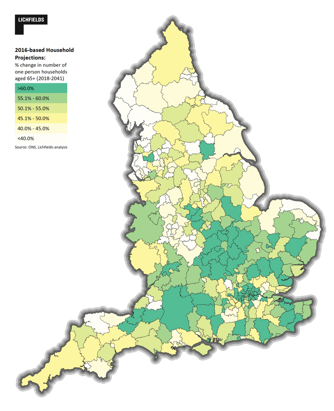
The new projections show that, there will be a significant increase in the number of one-person households by 2041, driven almost entirely by growth in one-person households over the age of 65. Due in large part to people living longer, one-person households in this age group will grow by 51% by 2041, accounting for 91% of the overall growth in the total number of one-person households.
However, growth in older households is not evenly-spread across the country; as Figure 1 shows, growth is mostly concentrated in the South of England and the Midlands, as well as in London, while in the North and South West there seems to be less variation. Still, more than half of English local authorities are projected to see the number of people aged 65 and over who are living alone increase by more than 50% by 2041.

Figure 1: Growth in in number of one-person households aged 65+ (2018-2041)

It is also interesting to consider changes in the number of younger households, specifically aged 25-34, particularly as these households are the focus of Government policies and programmes aimed at increasing homeownership (see our blog on entry-level exceptions for example).
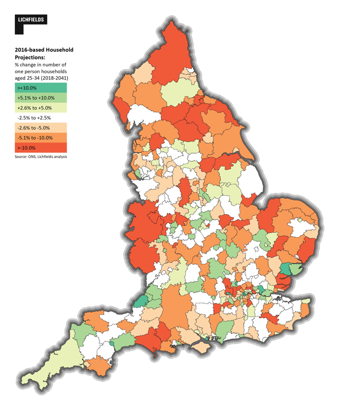
Across England, there will be just 1.7% growth in households in this age group over the period to 2041, and less than 1% growth in the number of single person households of the same age. Notably, both groups have projected declines of close to 10% by the year 2032; this reflects the demographic shifts of a smaller age-cohort coming through, with numbers roughly returning to their present levels by 2041. What is not accounted for in these statistics are the 1.8% of concealed households (e.g. adult children living at home) and sharing households identified in the 2011 Census.[2]
Figure 2 below shows the geography of the projected change in one-person households aged 25-35, and reflects a very different spatial pattern compared to Figure 1 above. Overall, just 45 local authorities will see an increase in one-person households over the period to 2041.

Figure 2: Change in in number of one-person households aged 25-34 (2018-2041)

The balance of different types of households projected also has implications for the mix of homes that will be needed, particularly at the local level.  The most significant increase (+139%) of any household type relates to those households made up of people over 90 who are living alone. This could suggest a challenge in terms of the current housing stock, and might also represent an opportunity for specialist housing developments for the elderly. However demand for this type of housing will also reflect factors other than the demography of the population, namely people’s willingness and ability to move in their old age.
The total number of households with children is projected to increase by only a small amount (1.9%) between 2018 and 2041. In simple terms, this suggests that the need for large sized housing may fall. However, multiple interrelated factors will also affect demand for larger housing. For example, the uneven geographical distribution of larger housing stock; so called ‘under occupancy’ meaning that one-person households might not live in one-bedroom homes as people may want spare rooms, and also, overcrowding within the existing stock.
Actual housing need and demand are subject to many different factors, not least changes in migration and birth rates, which can be linked to broader changes in government policy. Furthermore, housing demand is heavily influenced by the economic outlook. Nevertheless, it is important to consider the extent to which the housing market can and should adjust in terms of type and mix (and not just overall quantum) to accommodate the significant increases in older households, and the relative limited change among other age groups and household types.

For more information on Lichfields’ latest research on housing need, including entry level homes, contact Bethan Haynes or Matthew Spry.


[1]Household projections for England – household type projections: 2016-based

[2]What does the 2011 Census tell us about concealed families living in multi-family households in England and Wales?  

CONTINUE READING

Battlefield Registration – what is it trying to protect?
Of all the heritage designations which give protection to the historic environment, Registered Battlefields are surely the most esoteric and probably the least understood.  Listed Buildings and Conservation Areas are familiar to most; scheduled monuments cover archaeology and antiquities; Registered Parks and Gardens cover swathes of artfully arranged landscape, and Designated Wrecks add a dash of underwater allure.  But what does a Registered Battlefield actually protect?
Contrary to some assumptions, it doesn’t really aim to protect archaeology.  According to research funded by English Heritage (now Historic England)[1], no battlefield in England from before 1400 has turned up any confirmed archaeological material and yet almost a quarter of the English registered battlefields date from this period.  So, if a battlefield does not have to have archaeological remains what makes it special and a candidate for designation?  Why are 47 sites across England given the same protection in the Revised National Planning Policy Framework (paragraph  194) as Grade I listed buildings and World Heritage Sites? 
Historic England’s guidance for choosing battlefields for protection contains just two essential criteria[2]: was the battle important enough and do we know where it was fought?  The guidance goes on to suggest other factors (association with historical figures, archaeological survival, topographical integrity et al.) which might be nice to have but, essentially, battlefield registration is about linking an historical event to a location.  Unlike other designations, battlefield registration does not seek to protect something specifically created (e.g. a building, a garden, a ship) but rather focuses on an historical event and its association with a specific place.  There is though no uniform way in which this link is manifested.
At the Battle of Lansdown near Bath, the landscape is almost unchanged; the fields, hedgerows and field walls which the Royalists and Roundheads fought across and sheltered behind on 5th July 1643 survive and make it very easy to trace the events unfolding around you.  However, the Battle of Lansdown is exceptional in this regard.  A more typical example of a medieval battlefield might be Shrewsbury where the old open fields of 1403 have been enclosed and a remarkable commemorative church now stands near the heart of the fighting.  There is no obvious trace of the great clash which Shakespeare embellishes in Henry IV Part 1 and nothing other than the general landform which relates to the landscape of the time.
And yet… both have been considered to preserve the link between place and event; both allow the romantic imagination to people these places with massed armies risking (and losing) their lives for a cause.  In both instances through careful examination of the battlefield and historical sources, it is possible to understand how the battle played out across the landscape; to make a connection (both intellectual and imaginative) between the site and the events of a particular day. 
With this in mind, it is not immediately obvious what this might mean for managing battlefields, or making decisions regarding development on or in the vicinity of the battlefield.  How do you measure the impact of a proposal on the imaginative response to an event which has left little trace?  What are you trying to protect when making decisions about these sites?  Given that the sites have often changed considerably over the centuries, they can surely cope with a range of further changes without losing their ability to relate back to the events of the battle, the qualities for which they were Registered.
Recently, Lichfields achieved planning permission for a new water-treatment facility within the Registered area of the Battle of Otterburn, Northumberland.  The battle was fought on the evening of 19th August 1388 between an English army led by Harry “Hotspur” Percy and a Scottish army led by James, 2nd Earl of Douglas.  They had clashed outside Newcastle a few days earlier and Douglas had managed to seize Hotspur’s pennant, a great indignity according to the chivalric code of Medieval knights.  At Otterburn, Hotspur attacked in order to restore his honour with intense fighting which resulted in the death of Douglas but the defeat of the English army and Hotspur’s capture. 
The new water-treatment facility involves replacing an existing building with a larger but lower facility.  As a pre-1400 battle, archaeology on the site was not considered to be a significant issue but understanding how the current landscape related to what we know of the fourteenth-century landscape and the events of that August evening was essential to be able to gauge any impact.  The site in question sits on the north side of the road which both the Scottish and English armies had been following from Newcastle and is believed to be close to the location in which the English army drew up.  The core of the fighting took place further west while an English flanking manoeuvre followed an arc far to the North, taking the Scots by surprise to the North-West. 
The site of the water treatment facility, while close to the English lines, is in a location which, due to the local topography, is not prominent in key views across the battlefield landscape.  In our assessment the existing buildings were not considered to interfere with the open landscape which makes an important contribution to the appreciation of the course of the battle. 
Working with Northumbrian Water, we evaluated the degree of visual impact arising from the replacement buildings and incorporated a planting scheme which worked with the existing landscape character to soften any remaining visual impact.  We concluded that the development, while larger but lower than the existing buildings, would not interfere with the intellectual or imaginative appreciation of events that happened 630 years ago; therefore the scheme would not harm the significance of the battlefield. The end result was a set of proposals which were considered to be an acceptable development even though it is well within the boundary of the battlefield. 
It is only fair to say that Historic England and Northumberland County Council’s archaeology service both felt that that the new building represented ‘less than substantial harm’ to the battlefield which could be justified by other public benefits. This appears to have been based on the building being larger than the existing building, but they did not specify their reasoning in terms of an understanding of the specifics of the battlefield.
To conclude, a final thought on archaeology.  While Historic England’s research has indicated that finding any archaeological material related to a fourteenth-century battle is highly unlikely, the planning permission for Otterburn includes a condition for an archaeological metal-detector survey of the site.  On a precautionary basis this is perhaps not unreasonable, but it may respond more to a desire to find a tangible connection to this remarkable event than a realistic assessment of archaeological potential.  Of course, if anything from the battle is found, this will be the earliest securely identified battlefield artefact in England!
Nick Bridgland is a Heritage Director at Lichfields with 25 years’ experience in the sector.  For 10 years he led Historic England’s listing team for the North of England and held national responsibility for Battlefields, including writing the Battlefields Selection Guide and coordinating Historic England’s Battlefields Advisory Panel of external experts. 

[1] Foard, G & Morris, R “Archaeology of English Battlefields: Conflict in the Pre-Industrial Landscape”, CBA Research Report 168, 2014.[2] Battlefields Selection Guide


CONTINUE READING

What is a listed building? A beginner’s guide

A recent Court of Appeal ruling has brought to the fore some of the misconceptions around what a listed building is and can be. The word ‘building’ itself can be misleading.

In England, listed buildings are designated under section 1 of the Planning (Listed Buildings and Conservation Areas) Act 1990 (“The Act”). In the case of Dill v The Secretary of State for Communities and Local Government, the appellant argued that Listed Building Consent was not required for the removal of two Grade II listed limestone piers with lead urns as they are not buildings. In the ruling, Lord Justice Hickinbottom stated that “…being on the list is determinative of the status of the subject matter as a listed building…”; furthermore, he also noted that the word ‘building’ is not defined in The Act but in section 336 of the Town and Country Planning Act 1990 which defines a building as: “’Building’ includes any structure or erection, any part of a building, as so defined, but does not include plant or machinery comprised within a building.”

Some misconceptions about what a listed building is includes:

1. They are all buildings.

Some listed buildings do not conform to what many of us would normally consider a ‘building’. Sculptures, cairns, water pumps, lamp-posts, telephone boxes, mileposts, the Cutty Sark (a suspended ship) and water troughs are all examples of listed buildings. Even a cobbled street, Conduit Hill in Rye, is a listed building as is the Grade II listed Victorian urinal illustrated above. This principle has been reiterated by the above-mentioned ruling.

2. They are old.

Generally speaking, buildings over 30 years old are eligible for listing (although there are exceptions). This means that as well as parts of Hadrian’s Wall, more recent buildings, such as the famous case of the post-modernist No. 1 Poultry (designed in the 1980s and built in the 1990s), can also be listed.

3. Only the building mentioned in the name of the list entry is listed.

Possibly, but this requires a case by case assessment as under The Act any object or structure fixed to the building is part of the listed building, unless specifically excluded in the list description; similarly, structures/objects within the curtilage may also be part of the listing. Fixtures and fittings are also a consideration.

This is a particularly tricky area of listed building legislation and can require detailed research and expert input. Historic England has recently published advice on listed buildings and curtilage.

4. Only the exterior of the building is listed.

The listing (and therefore the relevant statutory requirements for listed buildings) relates to the interior of a building, its exterior and sometimes its curtilage. Therefore, unlike planning permission, Listed Building Consent may be required for internal works.

5. The listed building is only what is described in the list description.

Not correct. The list description was originally intended simply to help identify the building and sometimes only provides a brief description of the exterior; the interior may not even have been visited when it was assessed for listing (see point 4 above). Accordingly, the description is not a definitive account of the extent of the listed building or its special interest. An amendment made to The Act in 2013 allowed for new list entries to be more specific about where the special interest of the building lies and to define the extent of the listed building. However, currently Historic England applies this provision on a selective basis so this only applies to a relatively small number of listings at the moment. We discussed this in a recent blog on Leeds General Infirmary.

Amy Davidson is a Senior Heritage Consultant based in Lichfields’ London office.

CONTINUE READING