The principle of Functional Economic Market Areas (FEMAs) is of longstanding relevance for spatial and economic planning. However, until recently, it was not always being clearly applied in practice, even under the Regional Strategy regime: most local authorities produced economic evidence based on their local authority boundaries, and made general reference to their neighbouring authorities. However, the Government’s
Planning Practice Guidance (PPG) published in 2014 gave FEMAs far more prominence: it states that economic development needs should be assessed in relation to relevant FEMAs - that is, the spatial level at which local economies and markets actually operate (in most cases extending beyond administrative boundaries). In that sense, it is analogous to the role of Housing Market Areas (HMAs) in assessing housing need.
To support our clients to meet this requirement, NLP has developed
FEMAplan: a framework for assessing the scope and nature of FEMAs. Having applied this framework for some of the first post-PPG
FEMA mapping exercises across the country, it seemed like a good time to reflect on what we have learned, how this has shaped our thinking about the geography of local economies, and what this might mean for local authorities and their partners when it comes to planning for, and delivering, economic growth. Some key observations and reflections are set out below.
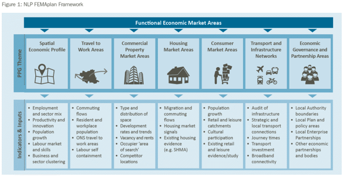
Across the guidance (PPG and previous Government notes), a number of key themes and factors are identified as useful approaches or ways of thinking about the economic geography of a local area. These themes shape FEMAplan and are summarised in the Figure below.
When undertaking FEMA analysis, explore the opportunity to
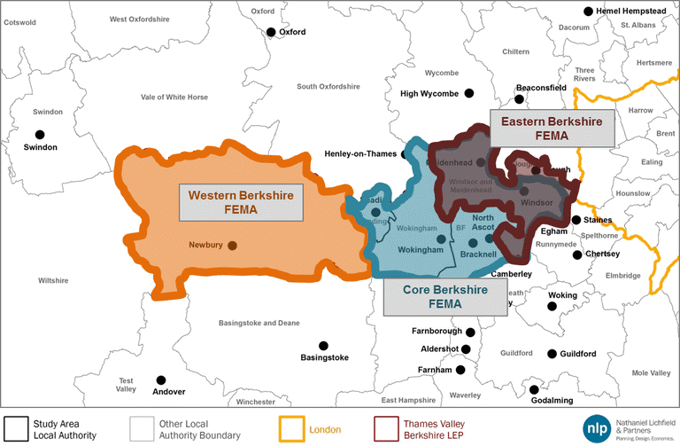
collaborate with neighbouring authorities and partners, shaping the scope of analysis together and sharing resources if possible. This approach has been taken in Thames Valley Berkshire where NLP recently supported the Thames Valley Berkshire Local Enterprise Partnership (LEP) and six Berkshire authorities to examine the economic linkages and relationships that exist across the area. This sub-regional partnership approach also worked well in
Sheffield and Rotherham,
Hertfordshire and Bedfordshire, using the latest data to revisit and re-examine established economic relationships and networks.
Be clear from the outset what the
purpose of the FEMA analysis is. Is it needed to define the geographical area of analysis for an economic strategy or employment land study, to inform Local Plan policies or Infrastructure Plans? FEMAplan has been used to explore a range of policy issues, from an assessment of the potential scope for new strategic employment sites within the ‘Gatwick Diamond’ to appraising current economic performance and potential across the
Greater Brighton and Coastal West Sussex area.
Draw on existing data and analysis as far as possible, with published studies often containing a wealth of intelligence and analysis. When it comes to synthesising this information with new intelligence and data, try and remain
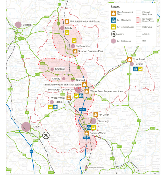
open to different ways of thinking about economic geographies and flows of people, goods and capital, particularly where this might deviate somewhat from the ‘status quo’. Our recent work in
Berkshire looked beyond the well-recognised concept of an M4 Western Corridor to identify three distinct sub-market areas operating within the Thames Valley (see Figure below), each with their own unique characteristics and profile of occupier demand.
Once a range of factors for mapping FEMAs has been chosen, collating the evidence into a single FEMA boundary can prove challenging; ultimately
an element of judgement will be required. One approach could be to consider the ‘degree’ of relationship or overlap with adjoining and nearby authorities across different indicators. In Bracknell Forest, this exercise found that functional linkages with adjoining Windsor & Maidenhead were stronger in commercial property and labour market terms than they were for housing and consumer markets. This evidence will help to determine where cross boundary cooperation will be required on particular strategic planning issues.
Analysing the spatial extent and nature of FEMAs also provides a great opportunity to use
powerful GIS, mapping and graphics tools to convey sometimes complex and unfamiliar geographies in a user friendly and digestible format. FEMAplan uses NLP’s market-leading
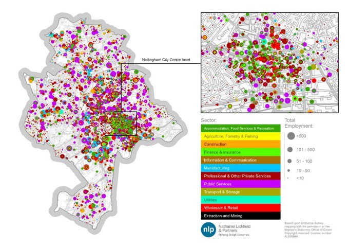
Spatial Analytics skills to capture a broad array of economic information and analysis in a visually appealing and creative way. For example, business sector mapping was used to identify the spatial distribution of business activity and clustering of sector specialisms across the
Nottingham Core and Outer Housing Market Area (HMA), as illustrated below. This intelligence was used to help shape a spatial strategy for accommodating business needs across the HMA.
As part of the process of streamlining local plans, recent recommendations made by the Government-appointed
Local Plans Expert Group pointed to the potential for government to update national evidence on the definition of HMAs, as well as aiming for coordination between economic and housing planning boundaries to facilitate more effective strategic planning. A sound understanding of economic geography will be key to the outcome of this recommendation being taken up, and we will be watching with interest to see how local planning authorities and their partners apply this evidence and use it to shape their development strategies, and their cross- boundary ‘duty to cooperate’ discussions in the months ahead.
Find out more about FEMAplan and how it can be used to examine functional economic geographies by
getting in touch.