The new National Planning Policy Framework (NPPF, published 17
th August 2026) introduced, a new development management policy, that applies from today regarding development near rail stations. This comes 569 days after the policy was first promulgated by former Chancellor Rachel Reeves MP in January 2025.
The draft policy we
analysed in December 2025 formally introduces what the Government describes as
“a default ‘yes’ for homes within reasonable walking distance of well-connected stations”.
The December 2025 draft was generally supported by the industry, but with some concerns at specific details of the policy. The final NPPF clarifies some policy elements and makes revisions on eligible stations and reduces the minimum densities required on sites.
This blog looks at what has changed, which stations are now included and the potential number of homes that could now be brought forward in different areas.
We assess that the policy could unlock land for up to 535,000 homes with scope to be as high as 570,000 homes. This is lower than the 630,000 homes we identified in our December 2025 analysis, largely due to the lower densities now introduced. However, the higher density threshold of 50 dwellings per hectare (dph) originally proposed was widely seen as being likely to render development unviable outside larger urban areas. Whilst the new policy has a lower headline number, it is one more likely to be viable than the higher – but ultimately not deliverable – estimate from last year.
As in the draft, there are four limbs to the policy by which development close to a well-connected railway station outside settlement boundaries can qualify for what is intended to be a clear ‘rules based’ pathway to securing a permission:
-
The station falls within the top 80 Travel to Work Areas (TTWAs) by Gross Value Added (GVA).
-
The station is ‘well connected’: there are four trains (or trams) an hour or two in one direction throughout the daytime in the normal weekday timetable, or there is a ‘reasonable prospect of achieving this frequency through planned upgrades or through agreement with the rail operator.
-
The development is physically well-related to the station or the settlement and within reasonable walking distance of the station.
-
The development achieves a minimum density of 35 dph across the net developable area of the site, with 45 dph for those with a frequency twice the minimum required for a well-connected station. There are exceptions for small sites where it is inappropriate or impossible and for traveller sites. Minimum densities should be exceeded where possible, and there is a requirement to make efficient use of land.
There is no requirement to demonstrate ‘unmet need’ or the absence of a five year housing land supply. This makes it a powerful tool for those seeking to bring forward development, particularly in areas that advanced local plans within the past five years under transitional arrangements, and where planned supply is likely to lag below the standard method assessment of need for some time.
What has been changed or clarified since the draft?
No change
The new policy applies to well-connected stations. The frequency of trains remains unchanged from the draft version, to meet the threshold:
"Railway stations and underground, tram and light rail stops…which, in the normal weekday timetable, are served (or have a reasonable prospect of being served due to planned upgrades or through agreement with the rail operator) throughout the daytime by at least four trains or trams per hour overall, or at least two trains or trams per hour in any one direction”.
Wider definition of ‘productive areas’
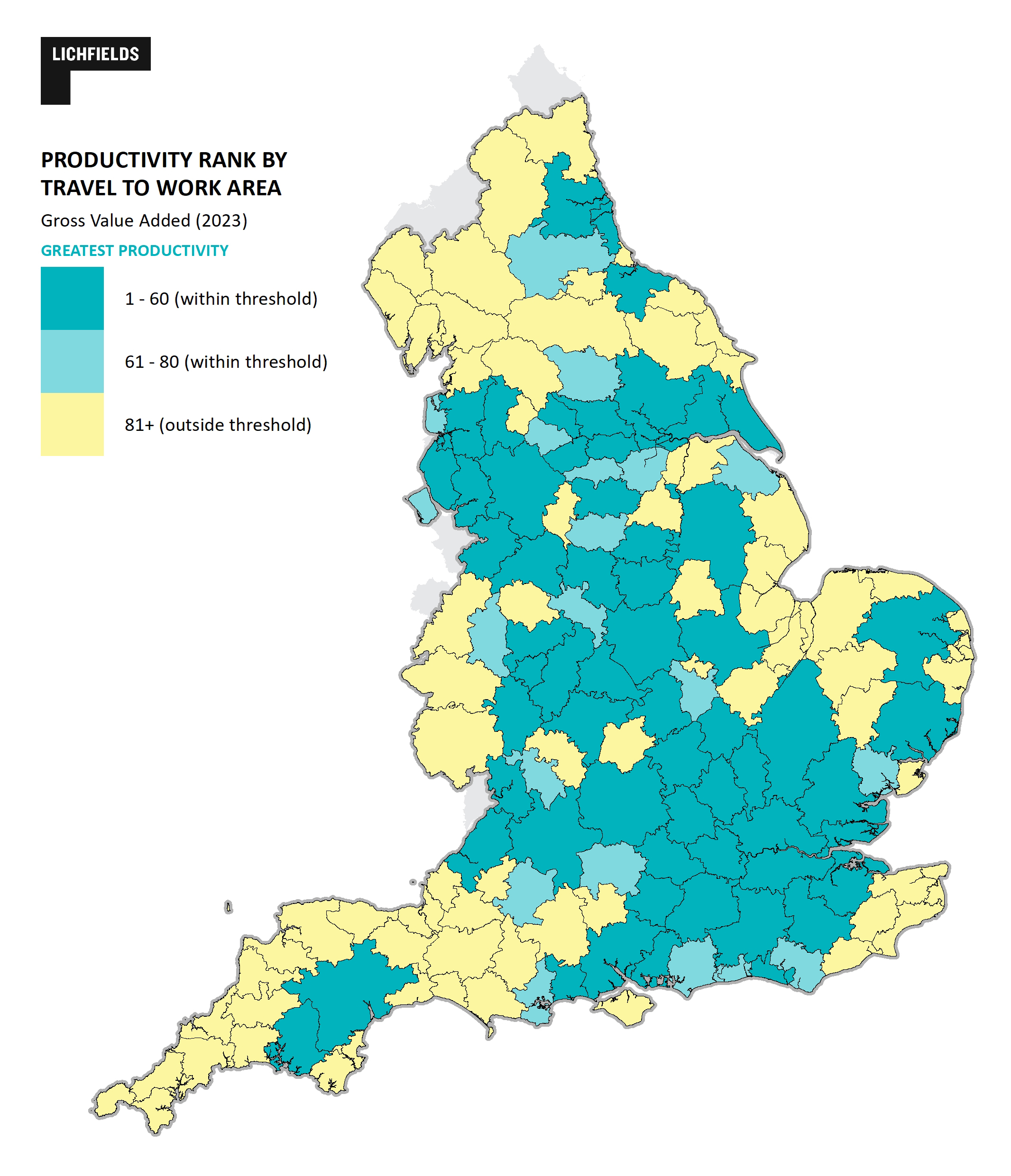
As we recommended in our December 2025 analysis, the Government has increased the number of travel to work areas (TTWA) in which the policy applies. This now encompasses the top 80 rather than originally drafted top 60 (out of 155) most productive areas in (or partially in) England. The twenty TTWAs now included bring in areas within Yorkshire and the Humber, as well as on the South Coast, North West and elsewhere. Widening the geography in this way increases the amount of land unlocked from around 21,100 hectares to 24,000 hectares. However, it still excludes part of Kent (including Ashford), Banbury, Evesham, much of the South West, large parts of East Anglia, the Midlands (e.g. Stafford) and many parts of the North West (including Burnley) and other parts of the north of England. In some areas this is a function of the (post Beeching cuts) number of railway stations in these areas, and others are outside of a ‘more productive’ travel to work area.
Figure 1. Top 80 Travel to Work Area by Gross Value Added (GVA 2023) located partially or fully within England.
Clearer definition of ‘reasonable walking distance’
The Government has retained the requirement for residential or mixed-use development to be within “reasonable walking distance” of an eligible station for this policy to apply. The framework clarifies that, in keeping with the Minister’s oral statement of December 2025, this is a distance of ‘around 800m’. It further asserts that only the area of the site that is within 800m of an eligible station will meet the policy criteria and density definition, including for employment and other mixed uses.
The 800-metre – or ten-minute walk is notably less than the 1,200m reasonable walking distance in the London Plan, and might in certain contexts be perceived as overly restrictive given mobility aids. Evidence shows that 76% of current rail users live beyond a ten-minute walk from their nearest station and 70% of residents in England live more than a (longer) fifteen-minute walk from their nearest railway station.
This is further reflected in local policies: 64% of local authorities already consider distances greater than 800 metres to be acceptable for new development.
Welcomed nuance on density
The final version of the policy diverts from the draft in adding some nuance to the treatment of densities for development around stations that is unlocked by the policy. This is welcomed as the initial singular approach to densities (a minimum of 50 dph) risked -as acknowledged in the policy paper - weakening the impact of the policy through
“unviable requirements in areas that cannot support them”.
The policy now states: Where development proposals for residential or mixed-use schemes are within reasonable walking distance of a well-connected station, a density of at least 35 dwellings per hectare should be achieved within the net developable area of the site [i.e. four trains through the day time per hour overall]. Higher densities – of at least 45 dwellings per hectare – should be achieved where the service frequency is at least twice that of the minimum required for a well-connected station [i.e. eight trains per hour].
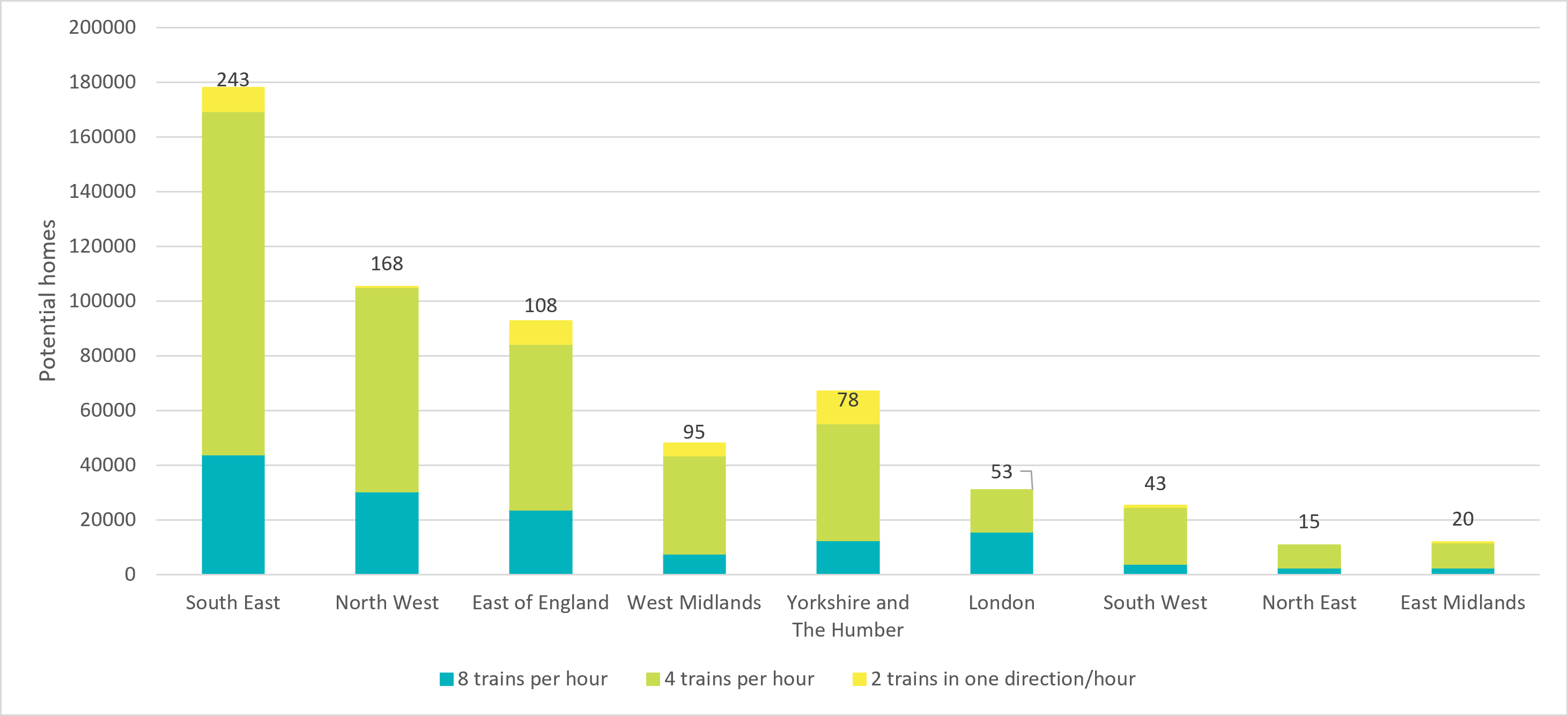
This welcome pragmatism means that many sites which would not have been viable or locally acceptable at 50 dph can now be planned at 35 dph. The majority of land unlocked by this policy will be around stations that have between four and eight trains per hour: 470 stations with an average of 40 hectares of non-built-up land (each equivalent to around 1,385 or more homes) would potentially be unlocked (see Figure 2). An additional 320 stations (with higher frequencies) will be required to deliver at a density of 45+ dph, but due to other constraints and the existing built up areas in which they are typically located, just 16 hectares or 736 homes per station would be unlocked. This excludes the potential of stations where current train frequences are below the necessary threshold but where there is potential to demonstrate a ‘reasonable prospect’ to meet the necessary frequency.
Figure 2 Number of potential homes at applicable near stations based on frequency
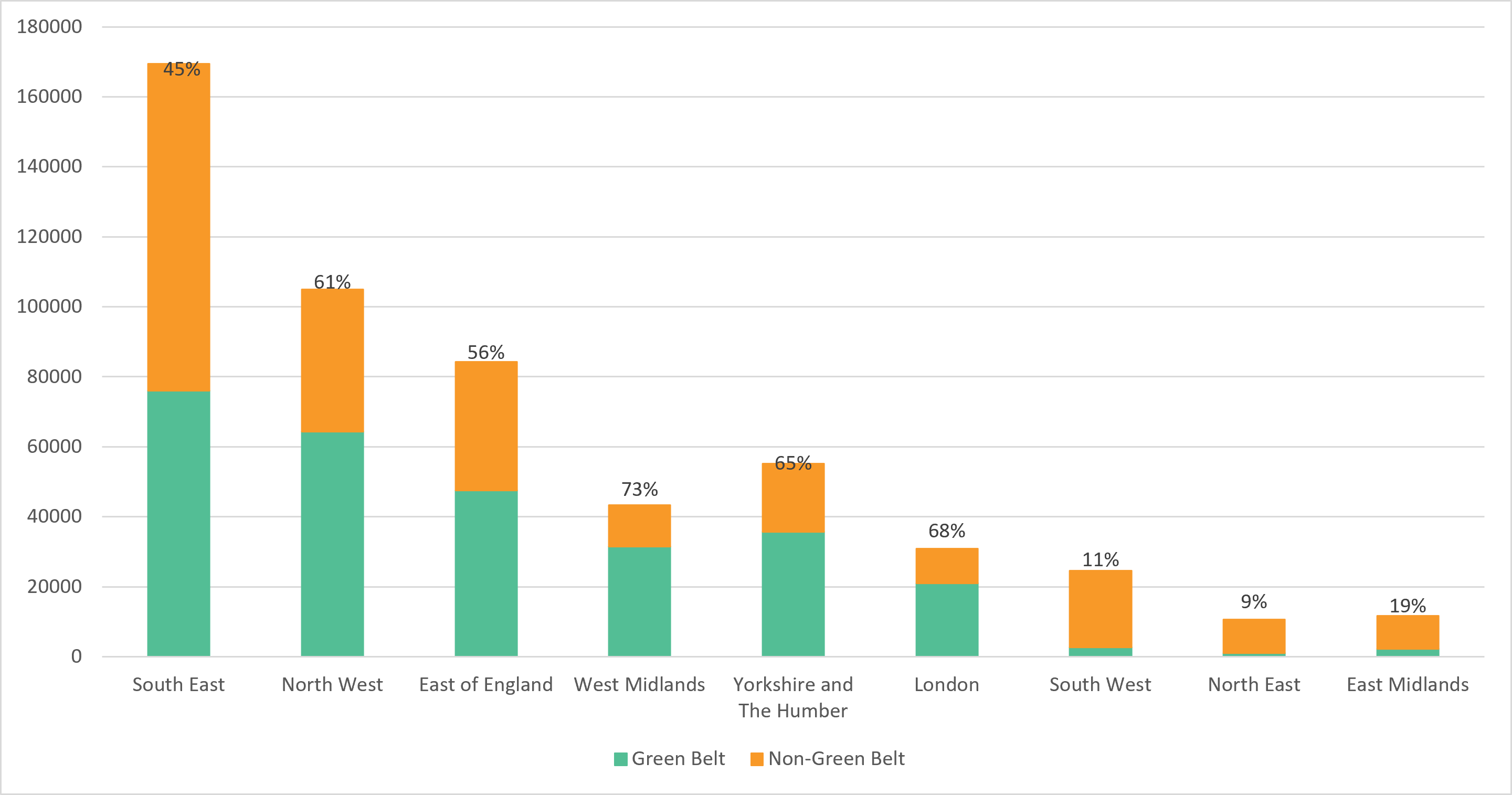
It is notable therefore that the policies have a very significant potential on Green Belt land in most areas: a point made by the Minister of State in the media round. 93,500 potential homes could be delivered via the policy on Green Belt land in the South East, and 73% of potential homes unlocked in the West Midlands would be on Green Belt land. Figure 3 shows the split between Green Belt and non Green Belt housing potential of the policy by region.
Figure 3 Number of potential homes on green belt land
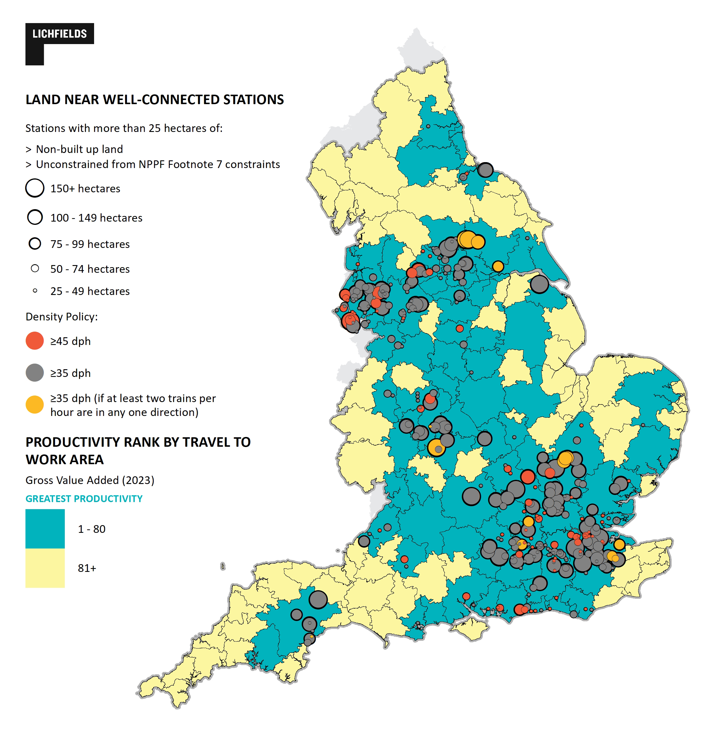
Figure 4 below shows the overall potential of the policy as drafted in terms of stations and potential land at the minimum densities and based on current train frequencies. Perhaps unsurprisingly, the greatest potential is around the greater south east, south of Birmingham and along the M62 / TransPennine corridor.
Figure 4. Land near stations unlocked by NPPF rail stations policy
Conclusions
The ‘development around rail stations’ policy has been something of a flagship: the headline in January 2025, in December 2025 and (‘full steam ahead’) with the new NPPF.
The consultation asked whether well connected stations were correctly defined. Our blog of December 2025 flagged the potential of the policy but noted questions over the TTWAs, the frequency thresholds and the minimum densities.
The Government has reflected and made some largely welcome adjustments that make it more likely the development potential of identified stations is capable of being realised, equivalent to 530,000 – 570,000 homes, with many more if currently under-serviced stations can attract more stopping services as a result of development. This is a lower headline number than our estimate of the December 2025 draft, but the reality – as we suggested at the time – is that the minimum 50dph density would have sterilised the potential of many sites. Better half a million that can be achieved than more that exists only on paper.
That said, the TTWA and frequency thresholds mean some locations remain out of the picture. The Burnham Government’s “growth in every postcode” mantra does not quite hold true when it comes to rail stations.
Footnotes
Per this HMT press release available here