The draft London Plan had its debut on Thursday 16 July, almost a year after the ‘Towards a new London Plan’ consultation was initially released (our thoughts on that consultation are set out in
Planning for industrial land in London: Time for a new approach?). The previous consultation hinted at potentially significant changes in the approach to protecting and planning for new industrial land in the capital. Below we set out some initial observations of whether the draft Plan delivers on that promise.
From a first reading, it seems that planning for industrial uses has clearly moved up on the Mayor’s agenda. In essence, the draft Plan is seeking to adopt a two-part strategy:
- to signal where industrial land can be released in a managed way to provide additional housing capacity in accessible, high-demand locations, and,
- using the Green Belt to ensure new industrial provision is brought forward.
For the latter, chapter 4 ‘Growing London’s economy in a way that benefits all’ highlights that the evidence shows increasing demand for industrial land in the capital due to the logistics requirements associated with changing shopping patterns and the associated requirements of an increasing population, alongside the need for infrastructure to support a growing economy.
In addition, it is stated that, reflecting on the constrained supply to accommodate both housing and economic needs, policy needs to balance the different requirements and ‘direct them to the most appropriate locations’, whilst minimising adverse impacts. The Plan makes particular reference to the key supporting infrastructure uses such as data centres and logistics, and their importance for the capital’s economic growth. Recognising that these uses are perceived to have disproportionate environmental impacts, the Plan emphasises the opportunity to harness the growth potential of industrial and related uses while also protecting the capital’s environment and serving the communities through proper planning and mitigation.
We consider each of the main policy provisions in more detail below.
Policy GLE2 – Supply of industrial land
Policy GLE2 directs Borough Local Plans to accommodate strategic needs (GLE2.A) following the strategic storage and distribution benchmarks set for each Property Market Area (‘PMA’) (Table 4.1) and by Borough (GLA: London Plan Industrial Evidence Paper, July 2026) (see interactive map below), alongside any sui generis uses need that are dependent on industrial land. These are presented as indicative demand figures to 2036 and 2050. Havering, Hillingdon, Barnet and Bexley stand out as all having identified needs above 75,000 sq.m (equating to c.20+ hectares) to 2036.
The methodology that underpins these estimates is presented in the Economic Uses Demand and Supply Study (2026), which utilises consumer expenditure and Gross Value Added (GVA) projections (based primarily on 2024 data) and applies a ratio to translate how much floorspace is needed based on the existing (2024 baseline) relationship between consumer expenditure, GVA and warehouse stock. However, using a ratio that might effectively reflect an already constrained position – which is clearly the case in terms of London’s current (and historic) stock of logistics space – to project future needs comes with the risk of underestimating future requirements.
It would seem prudent that a latent demand allowance should, as a minimum, be added to these estimates. The evidence suggests that an 8% vacancy rate was captured in 2024 and therefore there is no need for additional allowance, but some caution needs to be applied when relying on the average figure for the whole of London in just one year. A longer-term trend and one that reflects the different sub-geographies of London would seem a more robust approach.
In addition, given the pressures from other uses, and the fact that the draft Plan advocates clearly for some selective release of industrial land, the absence of any loss allowance as part of the assessment of future needs also appears problematic.
Figure 1 below presents the draft Plan’s indicative benchmarks for storage and distribution needs by Borough (and corresponding Property Market Area – PMA), but we would emphasise that these are likely to represent a minimum position in view of the factors outlined above.
Figure 1: Interactive map
Policy GLE2.B also encourages the further utilisation of existing industrial sites by suggesting re-activation of vacant premises and a review of brownfield and other designated land for intensification. In some ways, this carries over Policy E7 of the current London Plan on intensification (which is directed in more detail in Policies GLE2.G and GLE2.H). However, the evidence indicates that E7 has not significantly increased the amount of industrial floorspace, so it remains to be seen how such an approach can be made more effective through the next Plan. The new dimension is that Policy GLE2.B requires active collaboration across Boroughs within the same PMA by pooling their respective capacities and planning to re-provide capacity in advance of any release elsewhere. However, there is no specific guidance on how this process might be expected to work in practice, and would require very close coordination of respective Borough local plans.
GLE2.C retains the Strategic Industrial Locations (SIL) and Locally Significant Industrial Sites (LSIS) designations that have been a long-standing feature of the London Plan, but requires boundaries to be reviewed for the purposes of designating additional industrial land and releasing currently designated industrial land in appropriate locations. GLE2.D encourages designating existing storage and distribution sites that do not have such a designation at the moment as SIL/LSIS. This gives currently undesignated industrial site owners and promoters a clear basis to secure formal designation of land through the expansion of SILs/LSISs based on the provisions of Policy GLE2.C or GLE2.D, either at the Borough or potentially PMA level.
The strategy appears to be trying to ‘claw back’ some of the 18% loss of industrial land that has occurred during the last 20 years by formalising arrangements on currently undesignated industrial land. This approach also fits with the principle of repurposing land to better meet modern industrial business needs – with older central industrial locations giving way to residential development, and higher performing sites and distribution centres on the outskirts being brought into protective wrapper provided by SIL/LSIS designation. However, it remains to be seen whether just adjusting the boundaries of designations to reflect on the ground realities will actually lead to any meaningful increase in industrial capacity.
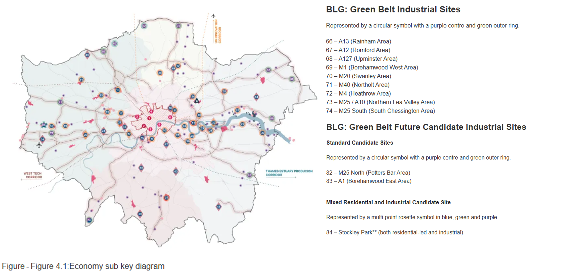
Ultimately, the key question that remains is where new industrial land in London can be accommodated. Policy GLE.E (alongside MBUL1 and PV7) encourages Green Belt releases in identified Broad Location of Growth (BLGs) and urges London Boroughs to release land in their Local Plans. The BLG Green Belt Industrial and ‘Future Candidate Industrial Sites’ (see Figure 2 below) reflect a range of locations around London, although not all align with the areas which have the greatest identified levels of need. We discuss this further below in the context of Policy PV7.
Policy GLE3 – Data centres
Policy GLE3 asks Boroughs to proactively allocate land for data centres in suitable locations based on specific criteria to meet the need, and if no such sites are identified, Policy GLE3.B encourages first to collaborate with neighbouring authorities within or outside London and secondly to consider grey belt or edge of Broad Locations for Growth (BLGs) in the Green Belt if no brownfield sites are available.
This is a significant shift, placing data centres at the centre of the planning system in London for the first time. The effect, in combination with Policy PV7, is to give more flexibility when considering data centre proposals within the Green Belt, on grey belt sites, or the edge of BLGs in the Green Belt where the other requirements of this policy are met. This differs from the approach to industrial uses, including storage and distribution, where, due to HGV trip generation, they are directed only within the identified Green Belt industrial BLGs. Therefore, it is implying a more flexible approach to planning for meeting data centre demand which is to be welcomed.
This flexibility will be essential. The
evidence base indicates that significant additional land-take may be required to facilitate data centre expansion between 2025 and 2050. This is to accommodate an approximate additional 5GW of projected demand between 2031 and 2050, reflecting current connection queue and energy network projections. Capacity up to 2030 is assumed to meet just 20% of future demand.
Policy PV4 – Strategic economic clusters and corridors
The Plan identifies 18 strategic economic clusters (Table 6.1), alongside those in the “key economic diagram” where Local Plans should focus their economic strategies and support the provision of necessary infrastructure, land uses, property and associated public space. In terms of development management, PV4.C encourages proposals to align with the priorities and the specialist sectors of each cluster alongside other supporting uses (and as appropriate housing).
The key clusters are focused primarily on health/life sciences, technology & innovation, media, education and sports & leisure, with the exception of three areas, namely the Heathrow Economic Area (Hillingdon, Hounslow), Great West Road/Golden Mile (Hounslow) and Dagenham East (Barking & Dagenham), where industrial uses are also included within the key sectors. Based on these examples, it is clear that there is a direction to promote industrial uses further on the outskirts of the capital and, combined with GLE2.D, to designate existing distribution sites on the periphery as SILs/LSISs and to contribute new supply as identified by PV7 (BLGs – GB Industrial Sites).
Policy PV5 – Industrial land supporting housing growth
Eight industrial sites within LSISs (Table 6.2) have been identified for further industrial releases for residential development; alongside ‘scattered’ non-designated industrial sites which are encouraged to be considered as brownfield land for residential development (PV5.C).
There may be overall planning merits to such an approach having regard to the draft Plan’s need to accommodate housing needs in the round, but as noted above, both planned and ‘windfall’ losses of scattered non-designated industrial sites leads to further under-accounting when it comes to the future needs equation and how capacity lost from the system through one policy will be adequately compensated by another.
Policy PV7 – Sustainable development and enhancement of the Green Belt
The draft Plan gives weight to strategic exceptional circumstances to release Green Belt to deliver major industrial-led (and/or residential) schemes in locations where a BLG is identified. As introduced through Policy GLE.E noted above, there are nine locations close to motorways identified as ‘BLGs – GB Industrial Sites’, two ‘BLG Green Belt Future Candidate Industrial Sites’, and one ‘Mixed Residential and Industrial Candidate Site’.
The draft Plan
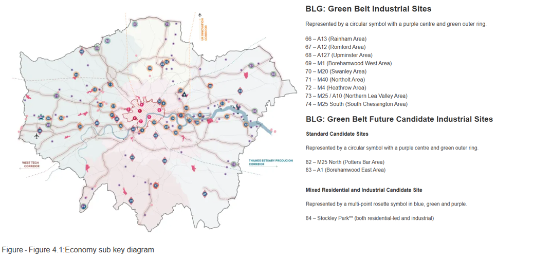
Annex C, Table C2: Industrial Green Belt Broad locations growth (BLG) reference table – (storage and distribution), provides more information for these sites to support the key diagram, lists 11 industrial Green Belt locations – albeit the referencing is not entirely consistent with those listed on the Economy sub key diagram. Extracts from the key diagram are provided below.
Figure 2: Green Belt Industrial Sites
Policy PV7.D (1) states that industrial development proposals in the Green Belt should demonstrate unmet needs that could not be met elsewhere as established by GLE2 Supply of industrial land. In addition, PV7.D (2) requires meeting the location tests set out in Box PV7A, where the key for industrial developments is that a benchmark distance of 2,500 metres of a junction with a suitable section of the strategic highways network shown to have adequate capacity and flow rates to accommodate additional lorry movements.
Last but not least, PV7.E states that when considering major development proposals outside of BLGs, significant weight should be attributed to a failure to meet any of the location tests set out in Box PV7A – C; and such schemes should demonstrate that they would not undermine the ability, directly or indirectly, to deliver any strategic BLG, including any necessary supporting infrastructure with particular focus (for non-residential schemes) on cumulative impacts on transport infrastructure, the delivery of prioritised transport improvements, impacts on sensitive heritage, biodiversity and landscape assets and parking provision (PV7.E.1-3). The draft Plan clearly anticipates a Plan-led BLG approach, even if they are not particularly well defined at this stage, and seeks to ensure that any industrial development beyond these does not undermine their ability to be delivered.
Conclusions
From our initial review of the draft Plan, industrial development and data centres feature much more prominently than before.
It is positive that there is a direction to revive underutilised, obsolete industrial locations that, due to their current characteristics and environs, realistically no longer meet modern business needs. This land is clearly signalled as being suitable for release to other uses.
However, it remains unclear whether the Plan will actually be capable of accommodating the industrial land needs identified, particularly strategic storage and distribution uses. The last two decades have seen significant losses of industrial land, while latent demand for industrial land over this period has gone unmet. The draft Plan is actively providing for further releases, both planned and of ‘scattered’ sites with no designations.
In this context, it remains to be seen whether extending SILs/LSISs boundaries to better reflect – and in theory protect – existing stock, and only a few targeted Green Belt releases associated with the identified BLGs, will necessarily 1) create the extra capacity needed, and 2) support development in the locations of greatest commercial market demand. The GLA may be hoping that the additional flexibility for Boroughs to plan across PMAs will assist in better balancing existing and new capacity, but such an approach depends on sufficient coordination and cooperation as individual Local Plans are brought forward, and may not provide sufficient certainty to the market. In any event, for the reasons noted above, the need requirements that have been set are likely to represent an under-estimate.
The commercial property sector has had high expectations for the next London Plan, and the consultation draft goes some way to addressing these by introducing a more sophisticated approach to industrial land policy more generally. However, in identifying needs, the draft Plan needs to go further in setting out more definitively how these needs will be met – currently the unmet needs issue is largely left unaddressed. The consequence is that ‘a BLG, or not a BLG’ will now be one of the over-riding questions for future industrial development, particularly for larger requirements on the outskirts of London, and those which interface with the Green Belt. The consultation is open until 15 October 2026.